We have recently completed several offshore surveys to capture detailed sea depth data (multibeam bathymetry) for sites in North Cornwall and Devon. Surveys were at St Ives Bay, Perranporth/the Gannel, the Camel Estuary, Bude and Bideford Bay/the Torridge Estuary.
Why multibeam bathymetry matters
Multibeam bathymetry is an advanced survey technique that uses sonar (sound waves) to create detailed (high resolution) maps of the seabed. The data collected provides a detailed picture of the shape of the seabed, e.g. its underwater topography. It also shows what the seabed is made of such as sand or rock (its composition), and how this sediment moves around (known as sediment dynamics).
If we can understand these features, we can better monitor and predict how our coastlines will change over time. Coastal areas are constantly shaped by natural events such as tides, storms, and sediment transport. The data we’ve collected will feed into models to help improve forecasts of future erosion, areas where sediment may be deposited, and the future shape of our shores.
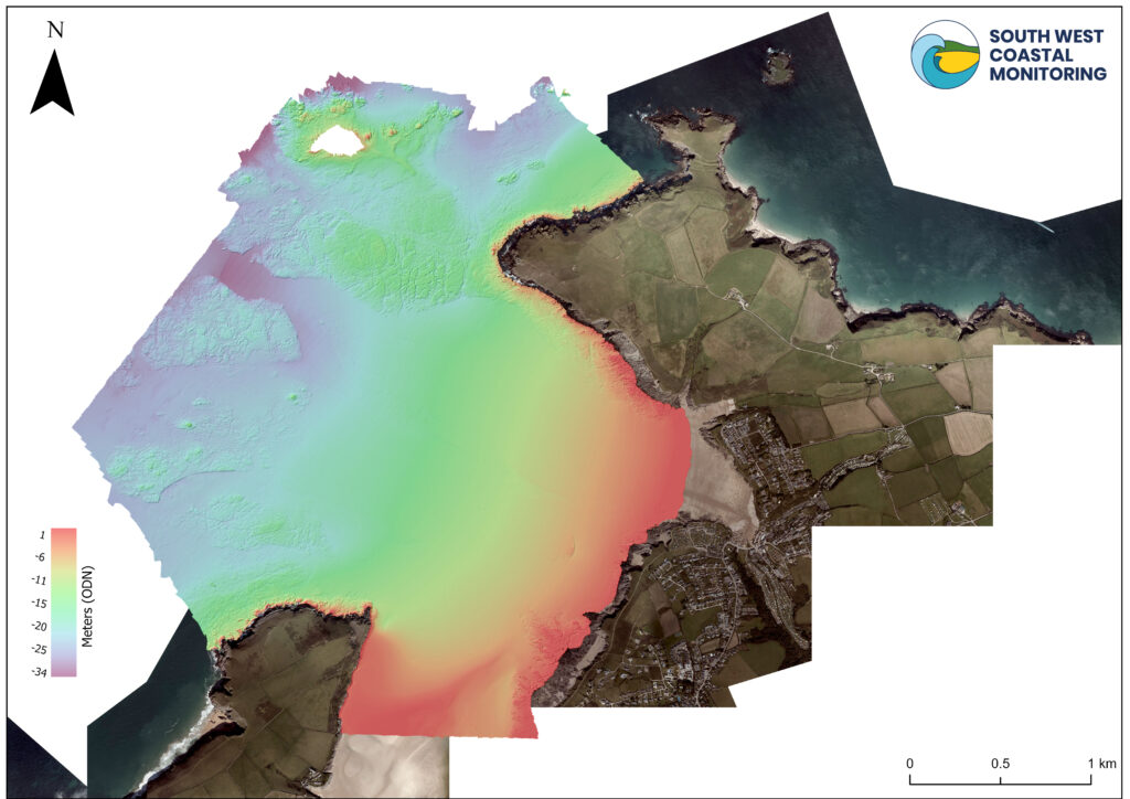
Figure 1 – Bathymetry data of the Camel Estuary, captured in September 2023. The red indicates the shallowest area, at ~1 metre, and the deepest areas are further out to sea reaching just under -34 metres, relative to Ordnance Datum Newlyn (ODN).
Supporting local coastal schemes
Our new bathymetry data plays a vital role in supporting local coastal management schemes. By identifying areas of sandy seabed versus hard rock formations, we can better inform decisions on coastal defence projects, habitat conservation, and sustainable development strategies. For example:
- St Ives Bay – This area has dynamic sediment movement (i.e. the sand moves frequently). Understanding where the sand builds up or erodes, helps better maintain navigational channels and support flood protection efforts.
- Perranporth/the Gannel – Movements of sediment in the estuary and in the intertidal area are crucial for managing tidal flow and protecting natural habitats such as dune systems.
- Camel Estuary – Our data will help this vital waterway balance conservation with sustainable tourism and fisheries.
- Bude – This coastline is well known for its geological diversity. Mapping hard rock areas helps assess coastal resilience against wave action and climate change impacts.
- Bideford Bay – This is a complex area with a large dune system to the north and a natural gravel barrier to the south, making it crucial we understand how this system works alongside a dynamic estuary.
Looking to the Future
This data is free to download from National Coastal Monitoring website. Let us know what you think of it and how you are using it. Together, we can increase our understanding of how the coast has changed and may evolve in the future.
Let's Keep In Touch
We’ll keep you up-to-date with all the latest news on this website, but we’d also love to be able to send the occasional update.
We promise we'll only use your details to tell you about what we’ve been doing.