Recently, our team embarked on an insightful journey with the Channel Coastal Observatory (South East Coastal Monitoring), aiming to level two crucial tide gauges situated in the Southwest region: the Etrometa in Port Isaac and the WaveRex Radar in Exmouth. The primary goal? To discover whether these gauges are experiencing any movement—a potential consequence of either the instrument itself shifting or the structure upon which it’s mounted subsiding, such as a harbour arm. This routine check holds immense importance as it helps us gauge the reliability of our measurements. It is conducted at least once every six years.
The process of levelling a tide gauge involves the placement of an RTK GNSS base on a flat surface of the gauge mount. This base station is left untouched for a minimum of 12 hours to capture an entire tidal cycle accurately. In Port Isaac, our Etrometa boasts multiple electrodes spaced 5 cm apart, enabling it to measure water conductivity, effectively penetrating the water to monitor waves and sea level.
To optimize our time and resources, we set up a base in North Cornwall’s Port Isaac on the initial day. Then, we journeyed eastward to Exmouth in South Devon to establish a second base for the WaveRadar REX, a tide gauge with distinct features. Unlike the Etrometa, the WaveRadar REX is designed to hover over the water, mounted on an overhanging structure. This innovative instrument continuously transmits signals and calculates water level by assessing the frequency variance between emitted and reflected signals.
The next day involves an inspection of both tide gauges to ensure they remain level and undisturbed from the previous day’s setup. Once we confirm their stability, we disassemble both bases, concluding the day’s work.
The process of levelling tide gauges not only showcases our commitment to accurate data collection, but highlights the intricacies involved in monitoring sea levels and waves. Through these efforts, we strive to ensure the reliability and precision of the measurements that contribute to our understanding of coastal dynamics.
…and the thrilling update that seals our efforts—after the thorough checks and rigorous measurements, we’re delighted to confirm that the gauges are maintaining their position within acceptable tolerance levels. This reassuring news means that we can continue our monitoring efforts confidently for several more years, ensuring our ongoing commitment to accurate and reliable data collection in understanding coastal dynamics.
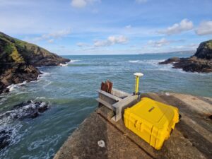
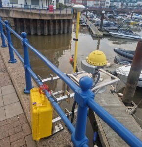
Figure 1 – Left – WaveRadar REX, Exmouth. Right – Etrometa at Port Isaac, both mounted with an R9 GNSS base.
Let's Keep In Touch
We’ll keep you up-to-date with all the latest news on this website, but we’d also love to be able to send the occasional update.
We promise we'll only use your details to tell you about what we’ve been doing.